Updated: 10/10/2026
Vinhomes Saigon Park location — the northwest gateway of Ho Chi Minh City
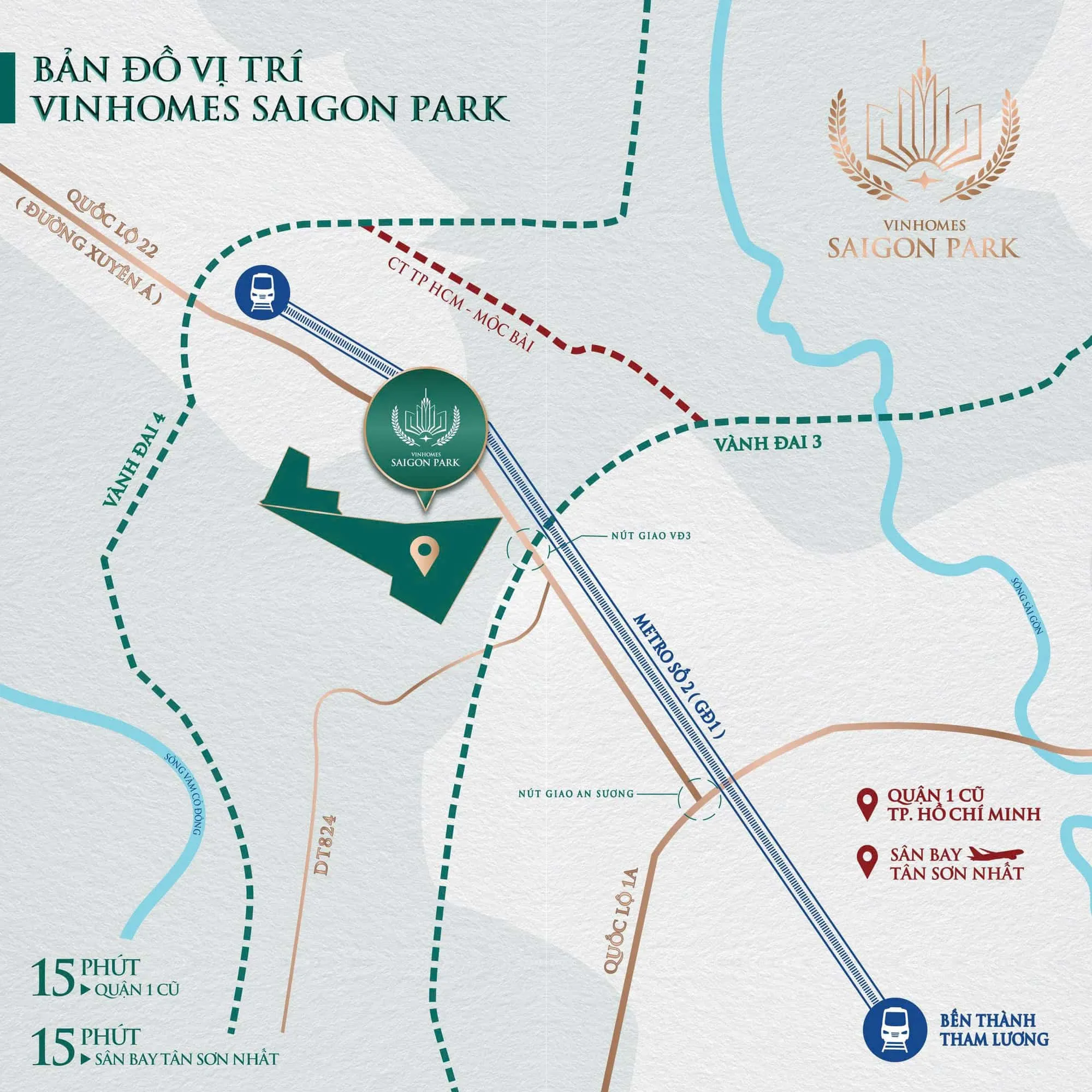
Vinhomes Saigon Park sits on the National Route 22 (Trans-Asia Highway) axis, where Metro Line 2, Ring Road 3 and the Ho Chi Minh City – Moc Bai Expressway all pass. This page sets out the address under the new and old commune names, the surrounding infrastructure and travel times per the developer’s materials.
Address and new / old commune names
Under the 2026 decisions (the 1/500 detailed plan and phase 1 land allocation), the project site is in Xuan Thoi Son commune, Ho Chi Minh City. Documents issued before the 2025 administrative reorganisation place the site in Tan Thoi Nhi commune, Hoc Mon district — which is why many people still search for the project as Vinhomes Hoc Mon.
The project lies southwest of National Route 22, within the city’s Northwest Urban Area under the 2012 1/2000 zoning plan.
Transport infrastructure around the project
| Project | Relation to the site | Milestone per developer materials |
|---|---|---|
| Metro Line 2 Ben Thanh – Tham Luong – Cu Chi | Station directly adjoining the project entrance | Phase 1 broke ground 15/01/2026, expected completion after 2030 |
| National Route 22 widening | Main axis in front of the project; An Suong – Ring Road 3 section widened to 60 m, 10 lanes, 7 flyovers | Expected start Q3/2026, completion 2028 |
| Ring Road 3 | Meets National Route 22 right next to the project | Hoc Mon – Cu Chi section started 07/2023, expected completion 2026 |
| Ho Chi Minh City – Moc Bai Expressway | North of the project | Started 19/12/2025, expected completion 2027–2028 |
| Ring Road 4 | West of the project | Starts 2026, expected completion 2028–2030 (materials differ) |
Dates are expected, per the developer’s materials, and may change.
Travel times
- To Ben Thanh station by Metro Line 2: about 20 minutes once the line is complete.
- To Tan Son Nhat Airport: the developer’s materials state 15 to 30 minutes depending on the version; in practice it depends on rush hour.
- Distance to the centre will change significantly once National Route 22 is widened and Metro Line 2 opens — for now, plan by road.
Get the location map & unit stock
Happy Land sends the location map, zone plans and the units currently available near the main road or parks — via Zalo, free of charge.
Frequently asked questions
Which commune is Vinhomes Saigon Park in?
Xuan Thoi Son commune, Ho Chi Minh City. Before 2025 the site belonged to Tan Thoi Nhi commune, Hoc Mon district.
Is the project near the metro?
Yes. According to the developer’s master plan, a Metro Line 2 station directly adjoins the project entrance. Phase 1 (Ben Thanh – Tham Luong) broke ground in 01/2026 and is expected to be completed after 2030.
How long does it take from Vinhomes Saigon Park to the airport?
About 15–30 minutes to Tan Son Nhat Airport per the developer’s materials; in practice it depends on the time of travel.
Which road is Vinhomes Saigon Park on?
On the National Route 22 (Trans-Asia Highway) axis, next to its interchange with Ring Road 3.